Railfanning Hotspots in the Twin Cities
Here are some different directions to railfanning spots in the Minneapolis - St Paul area. All of the maps link back to Bing maps so you can get more personalized directions for your railfanning. This guide generally will move from west to east...
Maps
AAA maps of the area can be helpful in finding your way and often show rail lines. The best state-wide map with rail lines is the Explore MN state road map, most every line listed and it is updated yearly, best part is the price free! Look for it at rest stops along the interstate freeways.
Google Maps
Bing Maps
Driving tips for the Twin Cities
Not from the area? Here are some tips to help you out...
Rush Hour: 6:30-9 am, 3:30-6:30 pm though it can easily go all day and late into the night
Traffic Reports: 88.5 FM on the 10s, the best in the cities - they will report every accident and jam
Transit Buses: They have the right of way by law and you don't want to mess with a 60' long artic...
Snow Plows - it is simple, stay back and stay alive. Give these folks room to work, they often work as plow gangs so if there is one another most likely is coming.
Road Construction - when you see ORANGE slow down! If it is warm out chances are you'll find construction crews at work on the roads. Please give them room, they are only trying to do their jobs!!
Train Freq. Ratings:
Low/Light - 0-10 trains daily
Medium/Moderate - 10-30 trains daily
High - 30+ trains daily
Note that this is variable and subject to change...
Safety:
Don't be stupid - trains can come on any track at anytime. Locomotives have a lot of power - if you come in contact with one the train will always win. Stay clear of the tracks, don't trespass, and stay safe.
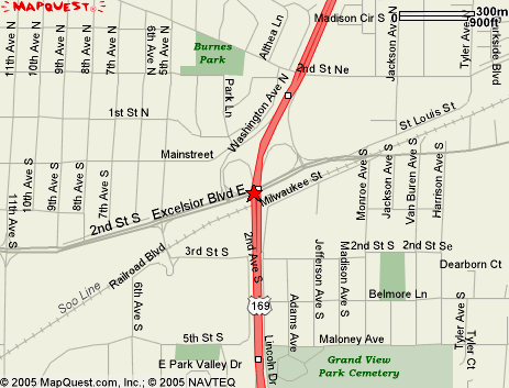
TCW terminal - Hopkins
This is where TCW stores their Twin Cities power - usually two to four units are stored here when the train crews are not working. Get off 169 at Excelsior Blvd. The terminal (well, office with service trucks) is across the tracks west of 169, there is a coffee shop in the old depot on the east side of the highway.
Train count: Low but storage point for TCW power in the Cities.
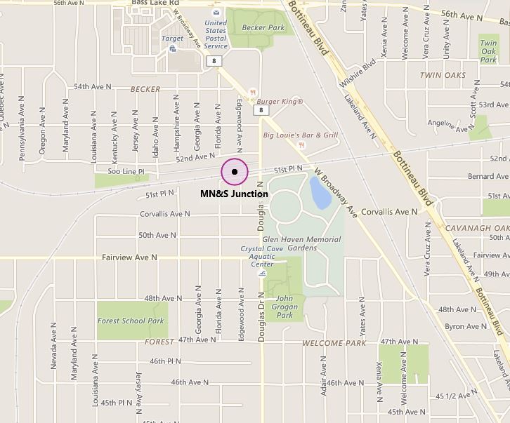
MNS Junction & Soo-BNSF Diamond - Crystal
Where the MNS line and Soo Paynesville Sub split, one can see all sorts of CP and Soo power on the mainline. Easy to find and observe from either parallel street or near-by park. Take 169 to 49th Ave; go west to Douglas (end of the road) and north to the tracks, junction a few hundred feet west. BNSF diamond is just west, can be viewed from parking lot. Note though that this lot is a part of Master Waste Services and Master Trucking and may be in active use at any time.
Trains: Moderate to high. Mainline sees regular trains, traffic ranges from medium to heavy. Lone round trip train on the MNS line (0630 MNS train) and TCW daily turn in the summers. One round trip on the BNSF line
**Side note** For those of you that know Mel-O honey, they were originally based right here at Douglas Drive.
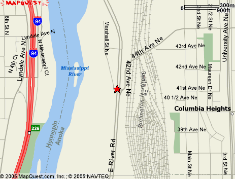
Northtown Yard - Fridley/Columbia Hts/Minneapolis
BNSF diesel shops located at East Rvier Road and 42nd Ave in Fridley. The yard itself is in Minneapolis, Friedly, and Columbia Heights. A large bridge crosses over the yard. Either side of the bridge has walking room, on the north is a large shoulder, on the south there is a sidewalk. These will give you the best views of the shops and motive power.
Train count - moderate to heavy, more for motive power photos.
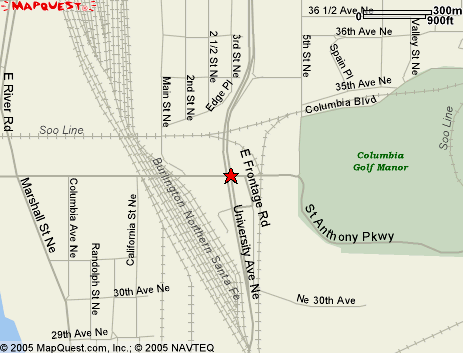
35th Ave Bridge - Minneapolis
This bridge is a good place to watch the traffic in and out of the yard, observe the Soo Line bridge across the yard. Not to mention BNSF stores their old power under the bridge. And easy parking can be found on either side.
Train count: High with yard trains and the mainline traffic all in one place.
University Junction - Minneapolis
On the interesction of University Ave NE and 27th Ave - it is east of the interestion to the tracks. Parking available in the business lots. Lots of CP and BNSF traffic, many tracks here and Northtown and Shoreham yards all add to the action. CP, BNSF, TCW, UP all go through here regularly, CN-WC is close by on the Humboldt transfers and MNNR comes in but usually at night. ICE may still serve Shoreham Intermodal. The Malt One SW1 located on NE 30th Ave. Due south of Northtown and 35th Ave.
Train count - heavy, esp in the afternoons.
14th and 15th Ave - Minneapolis
This is a pair of under and over passes, 14th is a ped bridge and 15th is a road underpass. The north end of BNSF's Union Yard is here and offers a good place to railfan, especially on the ped bridge. Day-time parking is tricky though when the Univeristy is in session. The bridge over 15th still has old GN logos painted on it under the rust.
Trains: Moderate to high
Dinkytown trench - Minneapolis
This is home to the Alco S4 on the U of M campus and also a small yard served by the MNNR. The S4 was used for moving coal cars, but since the plant has switched to natural gas the S4 is now stored in the former coal-unloading shed. At rare times the S4 will be outside running to make sure its still in working order. On the right will be a huge pedestrian bridge painted maroon and gold. Under it is the trench and coal plant. Parking is ahead to the right but often limited. At this point you will be on campus and parking is tight. It may be easier to go back into Dinkytown, park, and walk over. Yes, it is legitimate as there is a very popular walking trail down there - and have a look from the ground. Just be sure and look out for the trains as they cross the pedestrian path and access road a few times.
Trains: Low
Map - see above (15th Ave map) near SE 14th Ave and River Road.
Union Yard - Minneapolis
BNSF's smaller on-campus yard. Take University or 4th and continue to 15th. Take a right here, you can't miss the McDonalds at the intersection. From here continue on 15th until just before the rail bridge. Take a right and follow the road past the baseball diamonds and you will be paralleling the yard. Parking is free - just remember to park only where it is legal as it is amazing how fast one can get ticketed on campus.
Trains: Moderate and views are sometimes blocked by stored cars...
MAP - See above(15th Ave), yard along SE 8th St.
Milwaukee Road Depot, Pillsbury A Mill and Stone Arch Bridge- Minneapolis
This is site of the historic GN Stone Arch Bridge and the historic A Mill. Drive along 4th or University and watch for signs to the Stone Arch Bridge - it is very close to Central Ave. The A Mill is on the edge of the parking area for the bridge and the walking paths around it.
Trains: None - the last one left the A Mill in 2003 and the Bridge has been a walking path since the 90's. The Depot is now a hotel, conference center, and has a skating rink under the train shed.
A Mill - Off of Main St near University and Central
Milwaukee Road Depot - Downtown Minneapolis at Washington and 3rd
Bridge - connects the two (essentially) over the river
Talmage Ave - Minneapolis
This is one of the few road crossings of the BNSF mainline from Northtown to St Paul. This double track line sees regular BNSF and Soo trains. Parking along Talmage is usually plentiful.
Trains: High
St Anthony Junction - Minneapolis
Located just east of 280 and Kasota/Energy Park Drive this is where BNSF and MNNR cross. Can be a good place to see MNNR's GE and Alcos in service and the huge UP coal trains that use their line with helpers to get to the WC.
Trains: Frequent on the BNSF line, a few daily on the MNNR including the UP trains
East Minneapolis
The old yards here are now home to some light UP traffic as well as the RoadRailer loading/unloading areas. One can often find UP power laid up here. Take 280 to Kasota, go west about a mile and you'll find the faciluties
Trains: Moderate
MAP - see above (St Anthony), just a few hundred yards west
Como-Harriet Streetcar line - Minneapolis
A classic ride on a good selection of Twin City Rapid Transit streetcars including their newest addition, a PCC car. This short line is scenic and a good way to spend an hour or so as you might like to try to shoot some photos from around the area and the depot. The Lake Harriet Depot is located at West 42nd Street & Queen Avenue. The streetcar departs the depot going northwest and ends next to the Lakewood Cemetary.
Trains: Every 15 minutes when in service
Hiawatha Light Rail (Blue line) - Minneapolis
You can follow the tracks easily to downtown and south Mpls, from there they go to the airport and Mall of America. Along 5th St downtown, Hwy 55 in South Minneapolis from Franklin to 50th St station. The mile and a half tunnel under the airport is a highlight of the ride as is the elevated section through the Lake Street area. Parallel walk and bike path from downtown and past 50th St. station makes for easy photography
Trains: High - every 5-10 minutes depending on time of the day and day of the week.
Click here for a map
Hiawatha Switching District - Minneapolis
Easy to find, along Highway 55 south of downtown just past Lake St this canyon of grain elevators is served by the MNNR. Across Hwy 55 is the Hiawatha Line which opened in 2004. Creative photography along here can be achieved with the elevators, which are hard to find in most big cities.
Trains: two daily switch jobs in the busy season plus switchers at the General Mills and Scheier plants at 37th and 35th.
Midway Station - St Paul
Former location of Amtrak service in the Twin Cities until 2014 when all operations moved to St. Paul Union Depot in downtown. Exit I-94 at Cretin/Vandalia. Turn north (towards RockTenn paper) and turn right on University, left on Transfer road.
Train count: Moderate - MNNR uses this to get to their yard - the stations sits between the roundhouse and yard.
St. Paul Union Depot
The new location for Amtrak's Empire Builder, trains come at 7am [eastbound Empire Builder] and 10pm [w/b Builder], leave at 7.35am and close to 11pm. But you may see a late train, it is helpful to call ahead to see when the trains are scheduled to come through that day. You may also see UP and CP traffic, and in the distance along the river BNSF. If driving the depot is located at 214 4th Street East, and you can either park in downtown or under the depot (paid parking). You can also take the Green Line or bus routes 3, 16, 21, 54, or 94 which will drop you off at the depot.
MNNR Roundhouse - St Paul
Alco heaven - lots of Alcos and GE's based out of this classic roundhouse. Very close to the Amtrak station, instead of left on Transfer go right (road turns into Cleveland) The roundhouse is ¼ mile on the left. Check in at the office to get permission to shoot the trains - most of the power is stored outside.
Train count - Moderate plus lots of classic power
MNNR A Yard - St Paul
Here you can watch the Alcos and one of the BN/UP mains. Bridges at either end on Transfer Road [just north of the Amtrak station] and another on Raymond - to get to this one take either Energy Park Drive or University to Raymond.
Train count: Moderate at Raymond as it includes the BNSF line under the same bridge
Midway Stadium- St Paul
Midway Stadium has been torn down and the St. Paul Saints baseball team have moved to a new stadium in downtown St. Paul (adjacent to the Green line light rail servicing facilty). The double tracked St Paul and Midway subdivisions plus BNSF's Midway Intermodal yard border the former ballpark. Located on Energy Park Drive just west of Snelling.
Train count: High - with four mainline tracks you're bound to see plenty of trains
Bandana Square - St Paul
When you see the steam locomotive on the left marking the Bandana Square's entrances you know you're there. Inside the old NP shops there was a huge O Scale model railroad (has been relocated to a space adjacent to the old Amtrak Midway station). The parking ramp at Bandana Square also offers a good overhead viewing spot of the BNSF/Soo main and it's free!
Train count - High
Black Bear - 831 Como Avenue, St Paul
Fomerly home to the Black Bear Café this site still hosts the parking lot that is trackside and is an easy place to camp out and watch the trains cruise past. BNSF double track mainline with CP action as well - everything from intermodal to ore trains and more.
Trains: high - and it seems if you are on a streak it will stay that way on this line….
Jackson St Roundhouse (MN Transp. Museum) - St Paul
This is a great addition to the rail scene in the area and has really come a long way in the last couple years. With a great display inside the roundhouse as well as outside this is a great place to spend the afternoon, even on the brisk winter days. You can even ride on a caboose for a short 15-minute trip to from the roundhouse, over the turntable to the edge of their property and back. On busy days there will be BN and UP trains on the Midway subdivision next to the roundhouse.
Trains: Moderate
Robert Street Bridge - St Paul
Historic Lift Bridge in downtown St Paul on the UP line. Hard to miss and makes for good photos. Easy to find from Kellogg downtown…
Trains: Low to moderate, but with extremely slow track speeds it gives some time to set up if you do see one
East Hoffman and Pig's Eye - St Paul
Take 94 to eastbound 694. Go south on 94. Go into St Paul, across the Mississippi thru downtown. Get off @ Hwy 10/61 and go south about ½ mile to Warner road. Go right on Warner till you come to a large bridge over lots of tracks. Exit immediately after the bridge; it is named something like Child's road.
To get to Pig's Eye shops go straight past the CP entrance sign and stay on the public road. It is public till the fork so this is fair game for pics, it offers nice views of the ready tracks and light repair shops.
To get to Hoffman go back under the bridge on the way to leave, but swerve off onto the service road on right just before you get back of signal boxes. That too is public** and is open for shots. This is our best spot, onto Warner Rd. The lot is by a collection of tracks with almost all of our trains passing thru here. The bluffs make a great backdrop!
**Technically it is public but some railroad cops still think it is private - just a head's up that you may encounter them at this location
Trains High
Newport & Red Rock Spur - Newport
Good views, not very scenic but not hard to park on the street and watch the parade of trains. Highlights include the Soo scrap job, which is one of the last holdouts for local cabooses everyday. This train serves Newport and Northstar Steel (which has its own switchers - located about a mile north) plus Peavey (also with a switcher - follow the road around the left of Northstar to the end of the line) weekdays. Just off Hwy 61 and 12th alongside the river is the parallel road.
Trains: high traffic from BNSF, Soo, plus ICE and Amtrak's Empire Builder
Savage & Port Cargill
Along Highway 13 west of 35W one can find a large amount of grain and cement terminals that employ switchers - Cargill, Lehigh Cement (at Cliff Rd and 35W), Bunge, Harvest States and more all are in this short stretch of road. For a view of a historic river trestle turn right from Highway 13 onto Vernon Avenue and continue north (caution, this road is not maintained and will be a bumpy ride). At the end of the road is the Minnesota River and Dan Patch Line (MNS) Bridge. This swing bridge, built in 1910, hasn't been used by trains since 2007, but TCW is planning to restart operations across the bridge in the near future.
Trains: Low frequency but lots of industrial switchers
MNS Line
Operations on the northern end of the MNS Line consist of a daily CP local between Humboldt and St. Louis Park except on Wednesdays and Saturdays when this train goes further south to Auto Club Junction in Bloomington to interchange with Progressive Rail (PGR). PGR owns and operates the High Line between Auto Club Junction and the end of the line in South Minneapolis serving numerous industries. PGR's High Line Job operates every weekday. The High Line parallels Old Shakopee Road in Bloomington before turning straight north in between Lyndale and Nicollet Avenues. The line ends just north of the Crosstown Highway 62. At the southern end of the MNS Line PGR operates the daily Lakeville Turn between Northfield and the Air Lake Industrial Park in Lakeville. In between these two segments the MNS Line has been out-of-service since the 1990s, but the tracks are still visible in some places. In Burnsville you can see the historic Orchard Gardens Depot once used by the Dan Patch Line for passenger trains. On Dakota County Highway 5 (Kenwood Trail) the depot will be easily visible at 155th Street West.
Independent Locomotive Service - Bethal
This is a locomotive rebuilding and leasing company that serves the region with lease power - they specialize in shortline and industrial sized power. Their shops often have locomotives out back waiting for work. Located on the BNSF line heading to Duluth. Take MN 65 north from I-694 to County 24 / 237th Av. (About 25 miles) and turn left. Turn right on County 73 / University Av. Extension, and watch for their facility on the left on Main St (about a block north of 237th)
Trains: Moderate - but can offer good shots of ILS power at the shops
MAP COMING SOON
Coon Creek - Coon Rapids
Just north of Northtown this is the splitting point for the BNSF - west is St Cloud and eventually Seattle, north is Duluth and the Twin Ports. Easy viewing from public property.
Trains: frequent on the transcontinental route, plus fewer on the Duluth route though one will see trains from UP and CP on this line.
MAP COMING SOON
Westminster - St Paul
One of the few places with rail tunnels in the area. BNSF tunnels but one can see CP and UP use the area as well. Interesting views can be had from the south side of the area from the LaFayette Av. overpass. Parking lots are on either side of the bridge
Trains: Moderate to high
MAP COMING SOON
Wayzata
In addition to watching trains along BNSF's Wayzata Subdivision (also known as the Willmar Line) you can visit the historic Great Northern Depot in downtown and also get great views of Lake Minnetonka. The depot can be accessed via Lake Street and Grove Lane East. West of the depot walk along the Dakota Rail Trail and to the right you'll see the former Dakota Rail Yard where interchange was made with BN (later BNSF). The Dakota Rail Line to Hutchinson was abandoned in 2001.
Radio Stations
When you are waiting for those trains you need something to listen to... Here is a list of the radio stations the club radio is often tuned into when working on the model railroad or trackside...
770 & 106.5 Radio K - The U's award winning station, from indie rock to punk rock, reggae to rap, they play it. 770 during daylight hours, otherwise tune in to 106.5 in the inner city
90.3 & 106.7 KFAI - Fresh Air Radio - world beat afternoons are great and plenty of other eclectic shows. Listen to 90.3 on the westside, 106.5 on the eastside
91.1 MN Public Radio and NPR - the famous Car Talk is at 10 am Sat., 1 pm Sun....
89.9 KMOJ - Heart and Soul of the Twin Cities R&B plus jazz, reggae, & community news
88.5 Jazz88 is the one and only station for complete traffic during the rush - listen on the 10's
107.5 ¡Es K-BUENA - todo el latino toda la hora!
96.3 KQGO Home of the Minnesota Twins - baseball and trains go together so well
There is also plenty of talk and other commercial radio in the cities - just surf the dial or try http://www.osceolawis.com/links/News/Radio.htm - it is almost up to date in this era of ever changing commercial stations...
MN Railroad Radio Research
For great current scanner info from around the state click here
Note - scanner use in moving road vehicles is not allowed unless one holds a permit
Click here for the
MN RAIL GUIDE
TWIN PORTS RAILFAN GUIDE